Spent the night camped out at Sonoro Pass (Coordinates: N38 deg 19.776', W119 deg 38.101') after enjoying a great supper in the town of Bridgeport, doing laundry and enjoying a refreshing shower - see description below.
Another experience of great American generosity. A local man who lives in Bridgeport met two hikers at the post office and simply asked if they needed anything. Chickadee answered we sure could use a shower. He told them to come on over to their home and they could use their facilities. Then he and his wife opened up their home to at least 4 other hikers. We all enjoyed a great shower and some homemade brownies. Thank you Mollie & Steve.
Shirley and Gordon drove us up to the trailhead and we enjoyed hanging out until nightfall. This morning Hank's Sonora Pass Cafe was open again this morning and as usual, Shirley had pastries for all of us.
Will report on this hike today later.
WELCOME
Thank you for logging on. It is hoped that you will enjoy reading about our outdoor experiences from the Appalachian Trail in the East to the Pacific Crest Trail in the West and everything in between. If you have questions about Carl's gear or need information on backcountry hiking, the AT and/or PCT, don't hesitate to email either one of us: sgoodman5815@gmail.com or goodmanATRidgerunner@gmail.com.
6/27/08
6/26/08
DAY 60: Jun 26. 10 mi day: TOTAL Miles 1018.3


We had an easy 10 miles hike to Sonora Pass over 10,880 elevation. We will not reach this elevation again on the PCT. We came up to the pass and were greeted by Hank from Alto Palo who had a delicious layout of fruit and desserts. He calls his trail magic Sonora Pass Cafe. Also, Meadow Mary served up Chili and my baby had lots of cold drinks ready.
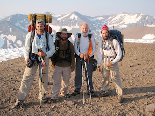
Photo #1 Slider, Gopher, Greybeard and Thrust on one of several ridges we passed over today; #2 Greybeard at 10,880 ft. elevation - the last time we will see elevation this high on the PCT; #3 Hank of Sonora Pass Cafe; #4 Cruisin, Billy Goat and Meadow Mary; #5 all of us enjoying the spread.
Keep hiking,
Greybeard
DAY 59 Reached 1,000 mile milestone: Total 1007


N 38deg 15.191, W 119 deg 35.980. Today's hike was as easy as yesterday's was hard. We have passed many beautiful (mosquito infested) meadows with big blue lakes. We finally climbed out of the last deep canyon and left the mosquitoes behind. WE HAVE REACHED A MILESTONE - 1000+ miles. Photo #1 me at the 1,000 mile marker laid down by another hiker. Photo #2 is Slider approaching my first cairn. This is just a marker in rocky areas helpful in locating the trail.
Keep hiking,
Keep hiking,
Greybeard
DAY 58, Jun.24, 20 miles: TOTAL 982.7


Today's hike was one of the most difficult with several passages and long, steep ups and downs and hordes of mosquitoes. The swampy area kept our feet soaked all day long. Shirley suggested I take Deet - and I am glad I did. We camped in Stubblefield Canyon Creek which was pleasant except for the MOSQUITOES. JZ and Gopher joined us. Coordinates N38 deg 03.566, W119 deg 35.432.
Photo #1 shows where we hike on snow-covered trail; #2 is Thrust fording a stream; #3 is me at another beautiful setting - there are so many.
Keep hiking
Greybeard
DAY 57: Mon. Jun 23.19.5 mi day. TOTAL 962.5


Hit the trail around 10 am with great terrain but hazy from the fires. We camped beneath Lodgepole Pines at Matterhorn Canyon Trail at 962.9 miles after forging Wilson Creek. We watched mule deer playing in the meadow around the camp all evening and the next morning. Coordinates: N38 deg 00.837, W 119 deg 24.893.
Photo #1 is the Mule Deer at our camp site. Photo #2 is one of the many beautiful waterfalls we encounter along the trail.
Keep hiking,
Greybeard
6/24/08
Yosemite National Park Photos from the PCT
Wildlife on the PCT
6/23/08
DAY 56: Mon. Jun 23. Back on the PCT


We got back on the PCT this morning around 10 am. Began our trek at Soda Spring, Tuolumne Meadows, east side of Yosemite NP. Heading toward Sonora Pass. Bad news: over 1,000 forest fires were started by lightning over the weekend. We fear that the smoke that is blowing over the Sierras will block some of the mountain vistas. Will update this post with coordinates as soon as possible.
Keep hiking,
Greybeard
DAY 55: Sun. Jun. 22 Half Dome, Yosemite NP


We reached our camp site near the Half Dome in Yosemite National Park on Saturday. Then we got up at 5 am to begin our ascent. Around 6 am I called Shirley from the top. The photos cannot describe the awesome beauty from an eagles eye point of view. We (NimblewillNomad, Slider, Gopher, Thrust and me) stayed up there for around 20 minutes taking photos and enjoying the scenery. Hoping to get a big breakfast down in Yosemite Valley, we headed down to Happy Isle Trail head and met Shirley and Gordon who were waiting for us at the parking lot. But the hike down was more strenuous than we expected and we missed the buffet breakfast in the Valley. Oh well, it (the Half Dome experience) was worth missing BB. This little side trip completed our John Muir Trail excursion.
Photo #1 the way to the top. #2 The cables you have to use to pull yourself up. #3 Sunrise over Yosemite National Park. #4 Me and Slider (I have my arms raised) out on the edge. #5 Greybeard, Gopher, Thrust, Nomad, Slider.
Enjoy the photos,
Keep hiking,
Greybeard
DAY 54: Fri, Jun 20. 28 mi. day: TOTAL 942.7


This entry will seem to be off in miles hiked due to the fact that we have decided to complete the John Muir Trail (JMT) http://en.wikipedia.org/wiki/John_Muir_Trail. We hiked into Tuolumne Meadows near Highway 120 in the Yosemite National Park (I'll post coordinates later). Much of the JMT parallels the PCT so we did not have to get off the Pacific Crest Trail to hike the Muir Trail. However we still had to cross snowfield after snowfield.
The hike into the Yosemite area cannot be adequately described. There are miles of massive granite domes towering over hundred of hiking trails and giant Sequoia trees.
Tomorrow we plan to complete the JMT by hiking up to the Half Dome area: http://www.thebackcountry.org/halfdome/ and actually climbing it on Sunday morning. When we come down from the Dome, we will hike into Happy Isles trail head and we will have completed the JMT.
Keep hiking,
Greybeard
6/20/08
DAY 53: June 19 - Day hikes: TOTAL 939


We slacked 8 miles yesterday and 22 miles today (Thursday, June 19)- mostly on the John Muir trail. The reason for this is that the Muir trail is so available (along the PCT and around the Postpile National Monument and since we have support), we wanted to complete the John Muir Trail as well as the PCT. So we made a point of hiking all the Muir trails in this area. More about John Muir later.
This is a photo of the memorial dedicated to John Muir. Will update later on the dates and coordinates where these were taken.
Keep hiking,
Greybeard
DAY 52: JUN 17- TOTAL 917.5 miles


good hike today with little elevation change into Red's Meadows. We passed through a large burn from 16 years ago. In August 1992 this fire (called the Rainbow Fire because it stared near Rainbow Falls) nearly destroyed Red's Meadows. We crossed so many small streams and snowfields that our shoes were still wet when we got into the Meadows.
Shirley and I plan to stay in a cabin tonight. We went into Mammoth Lakes to eat dinner, update this post and resupply. Plan to day hike for the next two days to get in several miles here at Mammoth Lakes. The John Muir Trail and the PCT are merged at this point.
The group photo shows hikers who hiked into Reds with me. From left to right is Gopher, Rapunzel, Thrust, Slider, Gordon (support person with his van) and NimblewillNomad. The second photo is of me walking across one of the beautiful bridges that span some of the snowmelt streams.
Keep Hiking,
Greybeard
6/18/08
FELLOW HIKERS


Here are some photos of hikers I have had the privilege of hiking with recently. Left is a photo in front of the John Muir Memorial. I am with Slider, Rapunzel, Nimblewill Nomad, Thrust and Gopher. Next is a photo at 11,760 ft elevation at Kearsarge Pass - Stubby, Moon Dog, Slider, and Pickles. The photo of Gil and others is at Kennedy Meadows. Then the photo of me sitting at the table at Kennedy Meadows with Sir Ken from OR. Just a sample of the great PCT class of 2008.
Keep hiking,
Greybeard
6/17/08
DAY 51. JUN 16 TOTAL MILES 900: 1/3 of the way


N 37 deg 31.760; W 118 deg 57.020: We left Vermillion Valley Resort at 10:34. I was so hungry last night I ate two meals plus ice cream. It was a great place. The trail out was not bad and we did 16+4 and went over Silver Pass to get to Purple Lake. We all got up at 5 am to get started by 6 am. I cannot count the large beautiful lakes we see every day and the ones near the passes are usually frozen. WE ARE 1/3 OF THE WAY TO CANADA!
Glissading over Silver Pass. We had several steep slopes coming off of Silver Pass so we glissaded instead of traversing the snowslopes. We just sat down on our behinds and slid down the steep slopes. It was a blast!
6/14/08
SunCups Photos and Description


 Hiking the snowfields is like walking on frozen waves which are called Suncups. This is a result of the sun melting troughs in the snow sometimes 2 ft deep. I found that maintaining my balance across this snow was easier without using my trekking poles. The trick is to stay on top of the waves and not drop your foot into a trough which could result in a broken leg, bad at 11,000 ft in the middle of nowhere. Still I found the new experience a lot of fun. Timing when hiking these areas is critical. Late in the afternoon the snow is too soft and difficult to maintain balance. Early morning made traction much better and safer.
Keep hiking,
Greybeard
6/11/08
DAY 43 & 44, Tues., June 10 and Weds., June 11 - ZERO Days in Lone Pine, CA
Spent a zero day Tuesday in a small, lovely little town, Lone Pine, CA. This is a place known for the Alabama Hills, where many western movies have been made. It is also a town nestled between the Inyo Mountain Range and the Eastern Sierra Mountain range. From our hotel you can look right at Mt. Whitney and the other high peaks of the Sierras. The temperature in Lone Pine yesterday was 100 deg but up on the mountain it was cold enough to freeze my shoes when I woke up on Monday morning. Quite a contrast.
Plan to get on the trail today (Weds., May 11). I'll be hiking on the John Muir Trail which parrallels the PCT for 200 or more miles. It will take me all day to reach the actual PCT because I'll be doing 9 miles on the Kearsarge trail just to reach the trail north. Also, the elevation we'll be climbing over is 11,760 ft.
Keep hiking,
Greybeard
6/10/08
Day 42, Mon., June 9,17.7 mi. TOTAL 790.2

After summiting Mt. Whitney on Sunday, we took a number of photos and got back to our tents. We packed up and hiked within range of Forrester Pass. Spent the night Sunday at Lake South America Trail. Forrester is the highest pass at 13,180 ft on the PCT. Locating the trail to the pass was more difficult than climbing it. The trail was spectacular once we got up there. Another challenge we have is traversing SunCups and Snowfields.
SunCups: A result of melting snow at different rates causing frozen waves often 2 ft deep or more and wide enough to drop a foot in (possibly breaking a leg). Often these "frozen seas" cover broad areas.
After clearing Forrester Pass, coming back down to 9,950 ft, we found ourselves facing 11,760 ft Kearsarge Pass and had to hike back down to 9,960 ft to Onion Valley Campground where Shirley and Gordon were waiting. She had cold Grape juice and pastries waiting for me. I will take a zero day tomorrow.
Keep hiking,
Greybeard
Subscribe to:
Posts (Atom)


